Exploring the Wonders of Infrared in Color Infrared Aerial Photography
Infrared technology has been around for decades, but it has only recently become more accessible to the masses, thanks to advancements in digital imaging. One application of this technology that has gained popularity in recent years is color infrared aerial photography. In this article, we will explore the wonders of infrared technology and how it is used in color infrared aerial photography.
Infrared radiation is a form of electromagnetic radiation that is invisible to the human eye. It lies just beyond the red end of the visible spectrum, with wavelengths ranging from 700 nanometers to 1 millimeter. Infrared radiation is emitted by all objects, including living vegetation. By capturing the reflection of this radiation, infrared cameras can produce images that highlight the differences in temperature and moisture content between different objects and materials.
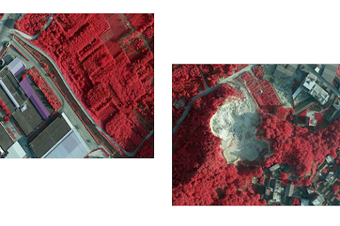
Color infrared aerial photography is a technique that uses a specialized camera to capture images of the Earth's surface from above. This technology is particularly useful for analyzing vegetation and land use. In color infrared aerial photography, vegetation appears in shades of red, while bare soil and water appear in shades of blue and black. This allows researchers and land managers to quickly identify changes in vegetation health and land use patterns.
One of the key benefits of infrared technology in color infrared aerial photography is its ability to identify areas of stressed or diseased vegetation. Healthy vegetation reflects more infrared radiation than stressed or diseased vegetation, which can appear as dark areas in the image. By analyzing these dark areas, researchers and land managers can identify areas of concern and take action to address issues such as pests, disease, or nutrient deficiencies.
Infrared technology is also useful in agriculture. By identifying areas of stress or disease in crops, farmers can take action to address the issue before it spreads and affects the entire crop. This can help to increase yields and reduce the need for pesticides or other chemical treatments.
Infrared technology is not without its limitations, however. One challenge is that it cannot penetrate clouds or other types of atmospheric interference. This can limit the usefulness of infrared imagery in areas with frequent cloud cover. Additionally, infrared images can be difficult to interpret without proper training and analysis.
Despite these challenges, infrared technology is a powerful tool in color infrared aerial photography. It allows researchers and land managers to quickly and accurately identify changes in vegetation health and land use patterns. As the technology continues to improve, it is likely that we will see even more applications of infrared technology in the field of aerial photography and beyond.
For more information or to order Color Infrared aerial photography products or services, please contact Feiyan Technology


评论
发表评论